Google's new 3D maps: 4 talking points
Google Maps will boast buzzy new features: Offline access and stunning 3D renderings of cityscapes. But is Apple about to boot it from your iPhone?

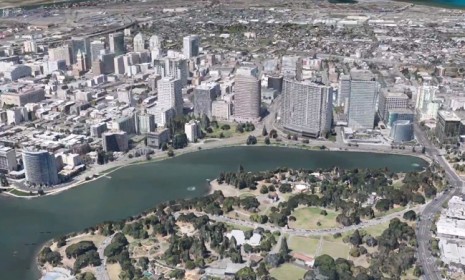
This week, the king of search (and future sci-fi glasses manufacturer) announced sweeping new changes to its ubiquitous mapping software, Google Maps. Among the new features: A three-dimensional version of Google Earth, allowing users to move around, rotate, and interact with computer-generated 3D images of a fully realized cityscape. Google's Peter Birth promises "magic": The new-and-improved Google Maps "creates the illusion you're flying over the city," he says. Here, four talking points:
1. Google's third dimension is visually stunning
Birth's demo took journalists on a 3D tour of San Francisco. (Watch it below.) We saw "every single building in the city, as well as plant life, statues, and other landmarks," says Nathan Olivarez-Giles at Wired. San Francisco's skeleton was compiled from overhead shots, and then overlaid with colors and textures to give it the look and feel of an eye-popping photograph. There's no set release date yet, though Google is hoping to have "communities of over 300 million people modeled by the end of the year." But really, what good are 3D maps, asks Mark Hachman at PC Mag. Do they look cool? Undoubtedly. But in lieu of real-world usability, these 3D maps seem more like a gimmick.
The Week
Escape your echo chamber. Get the facts behind the news, plus analysis from multiple perspectives.

Sign up for The Week's Free Newsletters
From our morning news briefing to a weekly Good News Newsletter, get the best of The Week delivered directly to your inbox.
From our morning news briefing to a weekly Good News Newsletter, get the best of The Week delivered directly to your inbox.
2. And you'll be able to access it offline with your smartphone
Lost in a part of town with spotty phone service? Google wants to make sure you never encounter that problem again, by making Google Maps available offline for the first time ever. This feature (initially available for Android phones only) will require some forethought: Before you hit the town, you must click on a portion of the city you're in to download the map to your phone in case the connection cuts out.
3. Google is photographing uncharted territory
So far, Google's camera-equipped vehicles have driven a total of 5 million miles to collect 20 petabytes of Street View imagery. Now Google wants to go off-road. "Until now, Google has used cars, trikes, snowmobiles, and trolleys to capture Street View imagery," says Joanna Stern at ABC News. The search giant's newest camera will be strapped to a hiker's back, and will capture 360 degree photographs. The 35-pound device could soon be spotted on a Google employee trudging down a backroad near you.
A free daily email with the biggest news stories of the day – and the best features from TheWeek.com
4. But the timing sure is curious...
There's a big, not-so-secret rumor underpinning Google's announcement: Apple is reportedly working on its own advanced mapping software, and purportedly plans to ditch Google Maps on iPhones and iPads. Some speculate that Apple's announcement could come as early as next week. "Gee, I wonder why [Google] previewed this now, rather than waiting until it actually shipped?" says John Gruber at Daring Fireball.
Preview the 3D tour of San Francisco:
-
 Why is Tulsi Gabbard trying to relitigate the 2020 election now?
Today's Big Question Trump has never conceded his loss that year
-
 The best fanfic that got published and went mainstream
The Week Recommends Fan fiction websites are a treasure trove of future darlings of publishing
-
 ‘Something close to a universal rallying cry’
Instant Opinion Opinion, comment and editorials of the day