

If the National Hurricane Center's word on Hurricane Laura's devastation isn't good enough, the Weather Channel has some visuals.
On Wednesday, the National Hurricane Center forecast the Louisiana and eastern Texas coasts would see an "unsurvivable storm surge" of 10–20 feet as a Category 4 Laura pulled in; Al Roker said he'd never heard the term used before. The Weather Channel also seemed unprepared for a surge of that magnitude. Its graphics could only show what a storm surge would look like at nine feet, but that was terrifying enough.
Subscribe to The Week
Escape your echo chamber. Get the facts behind the news, plus analysis from multiple perspectives.

Sign up for The Week's Free Newsletters
From our morning news briefing to a weekly Good News Newsletter, get the best of The Week delivered directly to your inbox.
From our morning news briefing to a weekly Good News Newsletter, get the best of The Week delivered directly to your inbox.
Create an account with the same email registered to your subscription to unlock access.
-
 5 brain-busting cartoons about RFK Jr.
Cartoons Artists take on candidate suitability, the Kennedy family, and more
-
 Right to roam: the battle to access England's green spaces
The Explainer A battle is being fought over access to England's green spaces
-
 Crossword: May 12, 2024
The Week's daily crossword


-
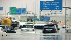 Arid Gulf states hit with year's worth of rain
Speed Read The historic flooding in Dubai is tied to climate change
-
 EPA limits carcinogenic emissions at 218 US plants
Speed Read The new rule aims to reduce cancer-causing air pollution in areas like Louisiana's 'Cancer Alley'
-
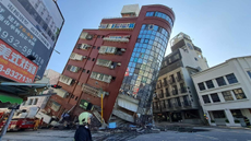 Strong Taiwan earthquake kills 9, injures hundreds
Speed Read At magnitude 7.4, this was Taiwan's biggest earthquake in 25 years
-
 EPA sets auto pollution rule that boosts EVs
Speed Read The Biden administration's new rules will push US automakers toward electric vehicles and hybrids
-
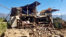 More than 150 people dead following earthquake in Nepal
Speed Read The death toll is expected to rise as rescue workers continue digging through rubble
-
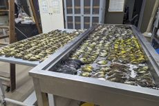 Nearly 1,000 birds dead in one night after striking building in Chicago
Speed Read The birds died after colliding with the McCormick Place convention center next to Lake Michigan
-
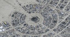 At least 1 dead at Burning Man as thousands remain stranded from flooding
Speed Read
-
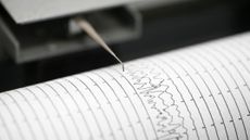 Earthquake rattles Southern California as Tropical Storm Hilary hits
Speed Read


