This is what it would look like if the world's 7 billion people lived in a single city
Imagine if all 7 billion of us lived as densely as the folks in New York City do

A free daily email with the biggest news stories of the day – and the best features from TheWeek.com
You are now subscribed
Your newsletter sign-up was successful

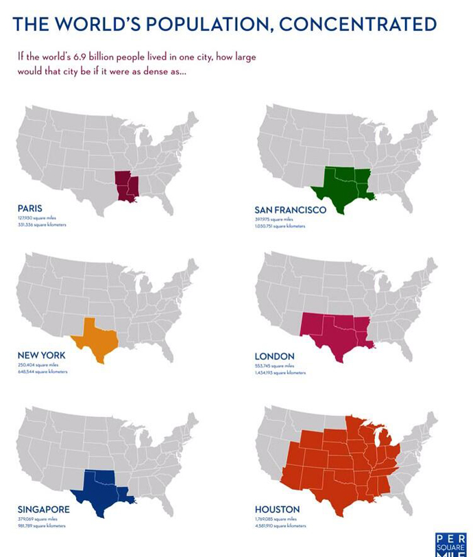
(To view a high-res version, click on the above image and zoom)
This map from Per Square Mile illustrates how big a city of 7 billion would be by comparing it to the population density of various cities around the world.
For example, if 7 billion people were placed in a high population density like the New York metro area (America's densest), the city would take over the entire state of Texas. With an area with much more urban sprawl, like Houston, the city would have to cover most of middle America.
The Week
Escape your echo chamber. Get the facts behind the news, plus analysis from multiple perspectives.

Sign up for The Week's Free Newsletters
From our morning news briefing to a weekly Good News Newsletter, get the best of The Week delivered directly to your inbox.
From our morning news briefing to a weekly Good News Newsletter, get the best of The Week delivered directly to your inbox.
What the map doesn't include, however, is the city's real limits (things like the amount of water sources, farm land, and other resources the population would need to sustain itself). Tim De Chant, who originally created the map and wrote about it a few years ago, said measuring the ecological footprint would prove "maddeningly difficult" for the subset of cities he used.
A separate map, however, does include ecological footprints for 9 different countries.
This article, by Kyle Kim, originally appeared in GlobalPost.
More from GlobalPost...
A free daily email with the biggest news stories of the day – and the best features from TheWeek.com
-
 The ‘ravenous’ demand for Cornish minerals
Under the Radar Growing need for critical minerals to power tech has intensified ‘appetite’ for lithium, which could be a ‘huge boon’ for local economy
-
 Why are election experts taking Trump’s midterm threats seriously?
IN THE SPOTLIGHT As the president muses about polling place deployments and a centralized electoral system aimed at one-party control, lawmakers are taking this administration at its word
-
 ‘Restaurateurs have become millionaires’
Instant Opinion Opinion, comment and editorials of the day