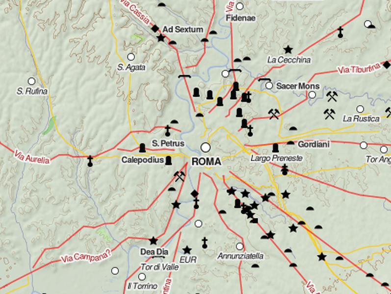
This interactive map of the Roman Empire is amazing


A free daily email with the biggest news stories of the day – and the best features from TheWeek.com
You are now subscribed
Your newsletter sign-up was successful
Everyone's at least heard of the Roman Empire. But have you ever looked closely at a map of it? Before the internet age, that took some digging.
But these days, we have not just an ordinary map, but a high-quality zoomable Google Maps-style topographical and political map displaying the the empire at its peak extent, stretching from Britannia to Arabia. Created by Johan Åhlfeldt, it includes roads, cities, towns, mines, and many other features. I found myself mesmerized clicking around and trying to figure out the history of various cities deep in the African desert, like Garama Metropolis.
Anyway, it's way cool, and highly absorbing. Check it out here.
The Week
Escape your echo chamber. Get the facts behind the news, plus analysis from multiple perspectives.

Sign up for The Week's Free Newsletters
From our morning news briefing to a weekly Good News Newsletter, get the best of The Week delivered directly to your inbox.
From our morning news briefing to a weekly Good News Newsletter, get the best of The Week delivered directly to your inbox.
A free daily email with the biggest news stories of the day – and the best features from TheWeek.com
Ryan Cooper is a national correspondent at TheWeek.com. His work has appeared in the Washington Monthly, The New Republic, and the Washington Post.
-
 ‘Those rights don’t exist to protect criminals’
Instant Opinion Opinion, comment and editorials of the day
-
 Key Bangladesh election returns old guard to power
Speed Read The Bangladesh Nationalist Party claimed a decisive victory
-
 Judge blocks Hegseth from punishing Kelly over video
Speed Read Defense Secretary Pete Hegseth pushed for the senator to be demoted over a video in which he reminds military officials they should refuse illegal orders
-
 Nobody seems surprised Wagner's Prigozhin died under suspicious circumstances
Speed Read
-
 Western mountain climbers allegedly left Pakistani porter to die on K2
Speed Read
-
 'Circular saw blades' divide controversial Rio Grande buoys installed by Texas governor
Speed Read
-
 Los Angeles city workers stage 1-day walkout over labor conditions
Speed Read
-
 Mega Millions jackpot climbs to an estimated $1.55 billion
Speed Read
-
 Bangladesh dealing with worst dengue fever outbreak on record
Speed Read
-
 Glacial outburst flooding in Juneau destroys homes
Speed Read
-
 Scotland seeking 'monster hunters' to search for fabled Loch Ness creature
Speed Read
