Sign up to get Today’s Best Articles in your inbox
Join 350,000+ subscribers and keep yourself informed with a selection of
The Week’s most interesting, enlightening and entertaining stories - plus daily puzzles.
You are now subscribed
Your newsletter sign-up was successful
Want to add more newsletters?
An account already exists for this email address, please log in.
Boko Haram: satellite images reveal extent of massacre
Before and after images show devastation of 'catastrophic proportions' and one town almost wiped off the map
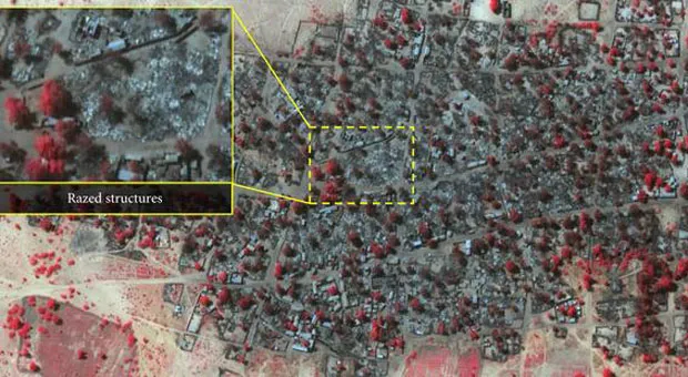
Satellite image released by Amnesty International reveal the extent of the attacks carried out by terrorist group Boko Haram on towns in northern Nigeria earlier this month.
The before and after images (click to enlarge) taken on 2 and 7 January show the neighbouring towns of Baga and Doron Baga razed to ground by the Islamist militants. The attacks left more than 3,700 homes, places of worship and other buildings damaged or destroyed.
PowerPoint Presentation
(Image credit: DigitalGlobe)
"These detailed images show devastation of catastrophic proportions in two towns, one of which was almost wiped off the map in the space of four days," said Nigerian researcher Daniel Eyre.
The Week
Escape your echo chamber. Get the facts behind the news, plus analysis from multiple perspectives.
Join more than 350,000 subscribers and keep yourself informed with a selection of The Week’s most interesting, enlightening and entertaining stories - plus daily puzzles.
Join more than 350,000 subscribers and keep yourself informed with a selection of The Week’s most interesting, enlightening and entertaining stories - plus daily puzzles.
Amnesty believes that this was Boko Haram's "largest and most destructive" attack in its violent history. However, the estimated death toll of 2,000 has been contested by the Nigerian government who said it was closer to 150.
But Amnesty argues that the images, combined with survivor accounts, "suggest that the final death toll could be much higher than this [government] figure".
The extent of the destruction matches the harrowing testimony given my residents who described how the militants began shooting indiscriminately, killing small children and a woman who was in labour.
"I don't know how many, but there were bodies everywhere we looked," one survivor said. There are also reports that the militants kidnapped over 300 women, and while some were later released, many of the younger women remain captive.
Sign up to get Today’s Best Articles in your inbox
A free daily email with the day’s biggest news and analysis – and the best features from TheWeek.com
Boko Haram attack: massacre in Nigerian army town
09 January
The terrorist group Boko Haram has left bodies rotting in the streets after an assault on the key town of Baga on the edge of Lake Chad.
Reports vary widely, but the death toll is estimated to be in the hundreds, with some reports placing it as high as 2,000.
The jihadists reportedly fired indiscriminately, attacking the key fishing and commercial centre with automatic weapons, petrol bomb and explosives.
"I escaped with my family in the car after seeing how Boko Haram was killing people ... I saw bodies in the street. Children and women, some were crying for help," Mohamed Bukar told Reuters.
A senior government official told the BBC that fleeing residents said the town was now "virtually non-existent" after buildings were set on fire, and that residents had not been given the chance to bury their dead.
This comes days after a multinational task force was forced to flee its base in the town. More than 10,000 people have escaped to neighbouring Chad, sparking fears of a major humanitarian disaster. A large number of those attempting to escape reportedly drowned while trying to cross Lake Chad.
The Islamist organisation is fighting to establish an Islamic state in Nigeria and the introduction of Sharia law. It now controls all three of Borno's borders with Niger, Chad and Cameroon, according to Al Jazeera.
It continues to step up its attacks, taking control of large swathes of north eastern Nigeria over the past year despite President Goodluck Jonathan's vow to defeat the militants. The country's military, which is the largest in West Africa, has also faced increasing criticism of its inability to deal with the threat.
The group regularly targets civilians, raping, murdering and kidnapping thousands of people. Last year it abducted over 200 schoolgirls from the village of Chibok.
The conflict has displaced over 1.5 million people and killed more than 10,000 last year.