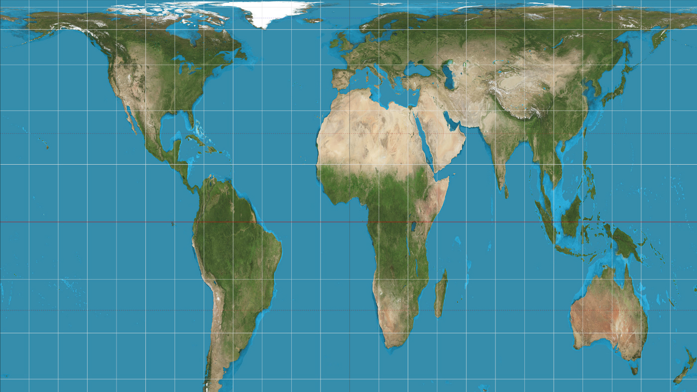
Boston schools ditch 'misleading' world map
Traditional Mercator projection abandoned in favour of more accurate Gall-Peters plan

A free daily email with the biggest news stories of the day – and the best features from TheWeek.com
You are now subscribed
Your newsletter sign-up was successful
Around 600 classrooms in Boston are set to ditch the widely used but highly distorted traditional map of the world in favour of a more accurate depiction of the globe.
Schools will use the Gall-Peters projection, which displays countries according to their actual size, in place of the Mercator projection, which shrinks Africa and South America and makes Europe and North America look much bigger than they actually are.
Boston public schools spokesman Colin Rose says the move is part of an ongoing effort to "decolonise the curriculum" and to challenge the "symbolic representation that put Europe at the centre of the world".
The Week
Escape your echo chamber. Get the facts behind the news, plus analysis from multiple perspectives.

Sign up for The Week's Free Newsletters
From our morning news briefing to a weekly Good News Newsletter, get the best of The Week delivered directly to your inbox.
From our morning news briefing to a weekly Good News Newsletter, get the best of The Week delivered directly to your inbox.
He added: "When you continue to show images of the places where people's heritage is rooted that are not accurate, that has an effect on students."
The Mercator map, published in 1569 by Flemish cartographer Gerardus Mercator, is the standard world map in almost all countries. However, it has come under criticism for its inaccurate and Eurocentric portrayal of the world's landmasses, with for example, Greenland much bigger than Africa despite being 14 times smaller, says the Boston Globe.
"And while Alaska appears to eclipse Mexico, the country's 49th state can actually fit inside of our nation's neighbour to the south with room to spare," adds the paper.
It also places western Europe in the middle of the map and shows North America and Europe to be bigger than South America and Africa, reports The Guardian.
A free daily email with the biggest news stories of the day – and the best features from TheWeek.com
The Gall-Peters projection was created in 1974 by German historian Arno Peters, using a projection made by the Scottish 19th-century cartographer James Gall.
It is an "equal-area" map that removes the distortions of the Mercator projection and instead more accurately distributes surface area to countries.
The Gall-Peters map has been used in schools before but this is the first time it will be used across an entire district as the standard world map.
-
 Political cartoons for February 18
Cartoons Wednesday’s political cartoons include the DOW, human replacement, and more
-
 The best music tours to book in 2026
The Week Recommends Must-see live shows to catch this year from Lily Allen to Florence + The Machine
-
 Gisèle Pelicot’s ‘extraordinarily courageous’ memoir is a ‘compelling’ read
In the Spotlight A Hymn to Life is a ‘riveting’ account of Pelicot’s ordeal and a ‘rousing feminist manifesto’
-
 Home Office worker accused of spiking mistress’s drink with abortion drug
Speed Read Darren Burke had failed to convince his girlfriend to terminate pregnancy
-
 In hock to Moscow: exploring Germany’s woeful energy policy
Speed Read Don’t expect Berlin to wean itself off Russian gas any time soon
-
 Were Covid restrictions dropped too soon?
Speed Read ‘Living with Covid’ is already proving problematic – just look at the travel chaos this week
-
 Inclusive Britain: a new strategy for tackling racism in the UK
Speed Read Government has revealed action plan setting out 74 steps that ministers will take
-
 Sandy Hook families vs. Remington: a small victory over the gunmakers
Speed Read Last week the families settled a lawsuit for $73m against the manufacturer
-
 Farmers vs. walkers: the battle over ‘Britain’s green and pleasant land’
Speed Read Updated Countryside Code tells farmers: ‘be nice, say hello, share the space’
-
 Motherhood: why are we putting it off?
Speed Read Stats show around 50% of women in England and Wales now don’t have children by 30
-
 Anti-Semitism in America: a case of double standards?
Speed Read Officials were strikingly reluctant to link Texas synagogue attack to anti-Semitism